|
Indian Creek into the Klamath |
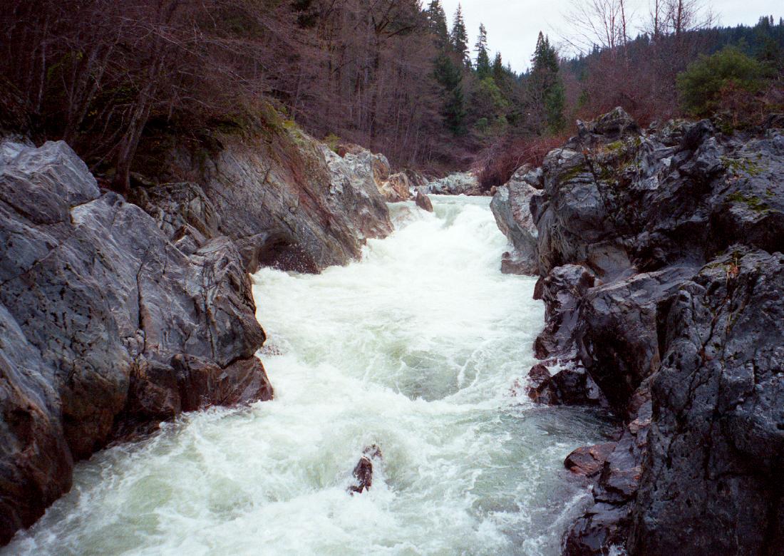
Indian Creek offers a good (fairly continuous) class III+ run, if you don't mind portaging once. Below the south and east fork confluences the creek drops swiftly over a boulder bed with occasional rock gardens. Around mile 1 comes a class IV- drop (so steep you might scout to determine the best route). After this rapids ease a bit. When you see the first bridge, a suspended railcar around mile 4, be on guard for a portage. If flows are high, start portaging at this first bridge, with aid of the road. If flows are low, you might elect to boat up to the lip of Puppy Falls, a class V+ (?) rock jumble. End your portage at or above the second bridge, a steel-girder span. You could put in there, as the Holbek writeup recommends, but that would make this run only 4 miles long, too short to be satisfying. Below the portage, rapids ease, although near the third bridge an old washed-out cement pillar presents a challenge. After that, rapids pick up again in a minigorge, verging on class IV- in places, at least at high flows. Doolittle Creek enters on the left around mile 6, and rapids ease again as you approach the houses and wood smoke of Happy Camp.
To reach take-out from I-5, drive east and then south on highway 96 until you reach Happy Camp. A good access point is just past the Indian Creek bridge. To reach take-out from highway 101 near Arcata, follow highway 299 to Willow Creek, turn north on highway 96, and continue to Happy Camp. To reach put-in from there, return to downtown Happy Camp and turn north onto Indian Creek Road. In about 7.5 miles you reach a bridge over the east fork. There is good parking beforehand. You can bump or line your boats down the east fork to the main creek. The south fork confluence is just upstream, so there is seldom enough water to put in any higher.
Creeks of the KlamathI was never a big fan of the Klamath area until discovering its sidecreeks. Boaters could spend an entire week touring the Creeks o' Klamath, as they might be called in an advertising brochure. Indian Creek, along with lower Clear Creek, are apparently two of the easier class III runs. Elk Creek and upper Clear Creek are more difficult class IV+ runs, and Lars Holbek rates Bluff Creek as class V-VI. Working downstream from I-5 to Happy Camp, the following creeks represent undocumented and perhaps undiscovered runs: Humbug Creek, Lumgrey Creek, Beaver Creek, Little Humbug Creek, Barkhouse Creek, Doggett Creek (no road nearby), McKinney Creek, Horse Creek, the (well-known) Scott River, O'Neil Creek (no road), Walker Creek (no road), Seiad Creek, Grider Creek, Portuguese Creek (no road), Fort Goff Creek (no road), Thompson Creek (no road), and another Horse Creek. From Happy Camp down to the Salmon confluence, the following creeks are encountered: Indian Creek (III+ 1P), Elk Creek (IV+ Ps), Oak Flat Creek (no road), Clear Creek (IV+ then III), Independence Creek (no road), King Creek (no road), Ukonom Creek (trail access), Swillip Creek (no road), Dillon Creek (no road), Ti Creek (no road), Sandy Bar Creek (no road), Stanshaw Creek (no road), Irving Creek (no road), and Rogers Creek (no road nearby). From the Salmon River down to the Trinity confluence, the following creeks are encountered: Perch Creek (no road), Wilder Creek (no road nearby), Cap Creek (good road access), Slate Creek (no road), Bluff Creek (described in Holbek's 3rd edition), and Hopkins Creek (no road). Below the Trinity confluence, these creeks are worth investigating: Pine Creek, Tully Creek (no road), Tectah Creek (no road nearby), Blue Creek (the largest drainage, starting in Klamath National Forest), and Turwar Creek (no road).
|
Creeks NavigationHomeRecommended Runs Map of Rivers Alphabetic Index Alphabetic Table Text Search
Sponsored Links
|