|
Russian River East Fork |
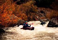
This is a good run if you are in the area, for example the afternoon before doing the Pillsbury run on the Eel. It is one of those engineering marvels from another era that is made possible by a coincidence of nature. The Eel River is only a few miles from the upper reaches of the Russian River drainage but it is separated by several hundred feet of elevation. PG&E saw this as an opportunity to extract energy from this water by drilling a tunnel thru the ridge that separates the two rivers. The cost of labor, the environmental impact, and the liability would probably preclude this project if it were proposed today. Eel River water is metered from Pillsbury reservoir to the much smaller Van Arsdale reservoir ten miles below. From there, water flows thru the ridge to a generating station in Potter Valley. This water then joins with the East Fork of the Russian River and about ten miles later it enters Mendocino reservoir. Without this additional water, the Russian River would be pitifully small during the summer months. Old-timers tell of some stretches of the river where no above-ground flow connected the occasional pools. The last three miles of the East Fork of the Russian River provide a delightful Class II+ run. This stretch is short, relatively continuous, contains a good “ender” spot, has an easy put-in and take-out, and a very easy shuttle. You might want to run it the day before the Pillsbury Run of the Eel, as a warm-up. Warning! There is a class V-VI rapid called Three Rock Falls by the locals that should probably be portaged by most people at most water levels. This area has taken the lives of several inner-tubers and there are signs warning boaters to portage around it. There is at least one undercut rock that would be difficult to avoid at lower water, and some logs to pin boats and swimmers in the final drop (1998). The put-in described here avoids this dangerous rapid. Highway 20 travels East from Highway 101 just north of Ukiah. It follows the north shore of Mendocino reservoir for the first few miles. The take-out is under the bridge where Highway 20 crosses the East Fork near the northeast corner of Mendocino reservoir. Look for a road heading down and to the north just East of the Bridge. This road is labeled “Lake Mendocino Recreation Area.” Follow this to the obvious turn-out (complete with trash can and picnic table) just beyond the bridge. The put-in is along Potter Valley Road, which goes north from Highway 20 less than two miles above the bridge. The road is well marked with a sign pointing to Pillsbury reservoir and the town of Potter Valley. You may put-in at either the first bridge where Potter Valley Road crosses the river, or about a mile further just below Three Rock Falls. You can recognize this second put-in by its parking lot, separated from the main road. A short dirt road goes to the right and toward the river. Up until here, the only parking has been at turn-outs on the road. The bridge put-in is much easier and makes the total trip less than two miles. The disadvantage is that you miss some excellent whitewater and the ender spot. The description below assumes that you choose the upper put-in just below Three Rock Falls. Park near the upper end of the parking lot and walk down on the trail that leaves from the north end of the lot. You may want walk a hundred yards upstream to look at Three Rock Falls, an impressive sight. Class I+ and II rapids begin right away. There are two sections above the bridge that probably rate close to II+. The ender spot is below the second of the more difficult sections. The river drops down a small falls. A number of us were able to “get vertical” without too much effort. You will need to experiment with it to find the best approach.
The stretch below the bridge (the lower put-in) is relatively easy for about a half mile. The toughest rapids are Class I+ and the biggest obstacles are strainers. Watch out for newly fallen trees. The Crux. The crux of the run occurs about a mile below the bridge as the river splits at an left-hand turn. The right-hand branch is a boulder-clogged chute that continues for several hundred meters. This is the toughest class II+ passage on the run and you might want to scout it from the island between the two branches. After a couple of Class II sections, you reach the slack reservoir water and, after a few more minutes of paddling, you will arrive at take-out.
|
Creeks NavigationHomeRecommended Runs Map of Rivers Alphabetic Index Alphabetic Table Text Search
Sponsored Links
|

