| |
| Stretch: |
Latrobe Road to Highway 16 at Rancho Murieta |
| Difficulty: |
Class III (one IV) with 2 portages, harder at higher flows |
| Distance: |
9.8 or 6.4 miles, 1 day |
| Flows: |
rafts 600 - 2000 cfs, kayaks 500 - 2500 cfs, IK minimum 400
|
| Gauge: |
flow measured at Michigan Bar
(MHB) |
| Gradient: |
24 fpm average (50 fpm near portage) |
| Put-in: |
on river right under Latrobe Road bridge, 340' |
| Take-out: |
at Michigan Bar bridge or at Highway 16 bridge, 100' |
| Shuttle: |
14 miles (20 minutes) one-way |
| Maps: |
Delorme N California, AAA Lake Tahoe Region,
Topo
|
| Season: |
winter and early spring, from rain and snowmelt |
| Agency: |
mostly private, BLM |
| Notes: |
© 1999 John Lester,
jwlester@ucdavis.edu |
Aside from the Lower American, the take-out for the Cosumnes River
is probably closer to downtown Sacramento than any other river: about 20 miles.
So this run should be quite popular.
There are a few problems: a major portage looms, locals are largely hostile,
and if the recommended flows in guidebooks are to be believed,
boatable flows are rare and short-lived.
Now that flows
are available electronically, the major difficulty is your access to the river.
The access situation on the Cosumnes is one of the worst in California.
A giant No Parking zone greets you at the put-in.
A commando put-in is recommended here.
Stop quickly and unload equipment, then drive the car back up the road
to where the no parking signs end.
Michigan Bar Road Bridge should be a legal access point,
but a gun-happy local prevents that.
The take-out has recently become plagued with another giant No Parking zone,
and the additional stinger here is that the County has
enacted a No Trespassing ordinance as well.
Until the access situation is resolved, a commando take-out is advised,
which is difficult owing to intense traffic and law enforcement on Highway 16.
Only .4 mile below put-in, boaters encounter Lower Falls,
several class IV drops followed by some class V++ drops.
The recommended portage is on the right bank,
because the left side is composed of uneven eroded bedrock.
Below the portage is a class IV, currently log-choked (1998),
and an entertaining class III gorge for about 5 miles.
The river flattens out before Michigan Bar bridge,
and gets really flat as it backs up behind a diversion dam 1.6 miles below.
This dam has been run, but most people portage on the left.
Class II rapids follow for almost 2 miles to the highway 16 bridge.
- mile
- 0
- Put in on either side of the bridge. The easiest way to the river
is a trail on the downstream shoulder of the north side of the bridge.
After you put in, look up at the house on the top of a knoll on
river right. You will be portaging right below that house.
- .4
- Portage!
A big sandbar on the right after one class II rapid signals the
start of the portage. You'll see a children's fort behind the
sandbar up on the bank. A class IV rapid below leads directly
into a class V+ waterfall right below here. You'll get a nice
view of the falls from the trail. The easiest portage is to
haul your boat up onto a broken flume that parallels the river
on the right. Portage along the flume, crossing a small creek
after 0.2 mile. If you plan on running the class IV rapid, find
a small cove below the falls. If you do not plan on running
this rapid, continue along the trail another 0.2 mile until you
reach a small trail leading down to an easy put-in. This flume
is on private property, but the landowners have been remarkably
friendly to boaters. Please be considerate of them.
- .7
- Carnage Gallery, class IV, Strainer Hazard!
A log is firmly jammed by the rootstock into a narrow slot in
the bottom of the riverbed. It will not come free anytime
soon, but parties who shall remain nameless have removed the
top 5 feet that protruded above a rock in the riverbed and some
of the rootstock. Depending on the flow you will probably
be able to float over the strainer, and you may not notice it.
The roots and remaining trunk still pose considerable foot
entrapment risk to a swimmer. There is a relatively calm pool
to put in at above this rapid, so anyone truly capable of
running a class IV rapid should not be swimming at the first
drop, but it should be noted that a swim here could be deadly.
The rapid itself is a long turbulent affair that is difficult
to scout from the trail, but it is easy to climb down and have
a look first. The name is due to the ability to sit in an eddy
at the bottom on river left and watch carnage happen.
- 1.2
- Unnamed Rapid, class III. Another long turbulent affair.
Sandy beach on the left below for recovery and possibly lunch.
- 1.3
- Cables from an old footbridge overhead, announcing the best part
of the run. After the cables, the river calms a bit, then
plunges down through two gorges with class II+ and III rapids,
some of which are steep and quite interesting. The riverbed is
quite narrow in places and swims can be fairly long because
there are few pools in the gorges. You pass by great scenery
and some interesting history. Keep your eyes peeled for
mine shafts, waterfalls, and old homestead sites. A great
surfable wave also awaits you in the middle of this section at
a very tight left hand bend in the river.
-
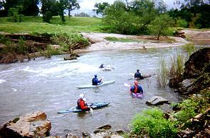 John Lester shows how to milk a wave
- 6.2
- About a quarter mile before Michigan Bar bridge, flatwater sets in.
- 6.4
- Michigan Bar Road Bridge. Armed Landowner Hazard.
The Cosumnes calms considerably here, and this would make a
great short day take-out, but the landowner here has reportedly
pointed a gun at boaters in the past. Taking out here is legal,
but seldom done by unarmed boaters.
- 7?
- Take the right channel where a small reservoir begins, backed up by...
- 8
- Diversion Dam Hazard. Take out on the left side and portage
easily across the island and put in below the dam. People have run
the dam, but it is not recommended; the portage is very easy.
- 8.1
- More interesting class II water with a fair number of play spots
the rest of the way to take-out.
- 9.6
- A great playspot is on the left at levels above about 1500 cfs and
can be reached by paddling upstream from the take-out. This point
is only 20 minutes from downtown Sacramento and could make a great
getaway after work in the spring if access can be restored.
- 9.8
- Take out at the highway 16 bridge. The best take-out used to be
on river left up to a parking area. Currently it might be better
to take out on the right, and walk to your parked car in a shopping
area of Rancho Murieta. Improvise!
To reach take-out, take the Power Inn Road exit off highway 50,
turn right onto Auburn Boulevard, and then veer right onto Highway 16
immediately after. Bradshaw and Sunrise can also be used to reach Highway 16.
Follow this road to Rancho Murieta. After passing through the stoplights,
you cross a bridge. This is the (hard to access) take-out.
To reach put-in from there, continue up Highway 16 east about 9 miles
to Old Sacramento Road. Turn left and travel about 2 miles to Latrobe
Road. Turn left, and you will reach the Cosumnes in about 3 miles.
Drop off gear quickly and get your vehicle out of the No Parking zone!
Upstream, the Cosumnes offers a run with more difficult class IV whitewater,
a portage around a waterfalls, and a long flatwater paddle to take-out.
More Information About the Cosumnes
Gauge Information:
Location: latitude 38°30'01", longitude -121°02'39"
in Sacramento County, Hydrologic Unit 18040013, on downstream side
of midstream pier of county bridge at Michigan Bar, 5.5 miles southwest of
Latrobe, and 12 miles downstream from confluence of north and middle Forks
of Cosumnes River, 168.09 feet above sea level You can see the gauge
as you paddle by.
Drainage Area: 536 miles² at Michigan Bar.
Maximum discharge: 93,000 cfs, 2 January 1997.
Minimum: zero flow at times in many years.
Remarks: Other than the small Jenkinson Lake Reservoir, the Cosumnes and
the Smith are the only rivers in California that are undammed. Flow partly
regulated since January 1955 by Jenkinson Lake, usable capacity, 40,570
acre-feet. A small amount of water is diverted out of basin through
Camp Creek and there are numerous small diversions upstream from station
for irrigation and domestic use.
|
|
Creeks Navigation
Home
Recommended Runs
Map of Rivers
Alphabetic Index
Alphabetic Table
Text Search
Sponsored Links
|
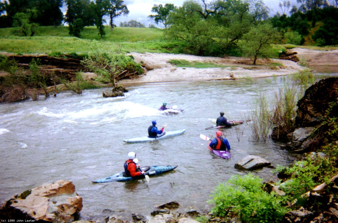 John Lester shows how to milk a wave