|
Russian River from Hopland to Asti |
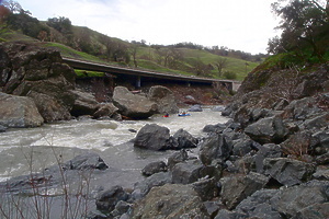
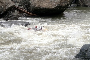
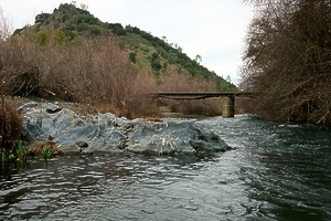
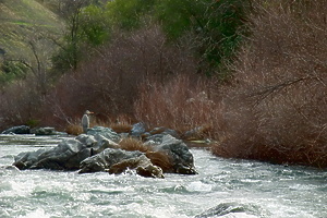
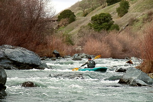
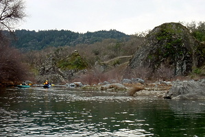
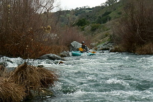
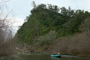
The Russian River from Hopland to Asti is moderately difficult but not too dangerous, scenic but not remote, easily accessible but not crowded. These features make the Russian River a wonderful resource for beginning and intermediate paddlers. Frog Woman Rock and Bone Yard are the most exciting and difficult rapids in this section. Put in at Pieta Creek and pass the pleasant petro palisade (mentioned below). Frog Woman Rock soon looms into view. The rapid at its base is not really runnable below 300 cfs, being too narrow for even a kayak. Above 300 cfs it is class III-IV. Immediately below Frog Woman Rock comes Bone Yard, AKA Graveyard, a rock slalom at low flow, and a bunch of big holes at high flow. Photos © 2010 Brendan Curran.
The section below Comminsky Station has less brush than upstream and is runnable even at low flows around 200 cfs. With many technical class II+ rapids and easy access, it is a good choice in the fall when little else is running. The bridge below Comminsky put-in is dangerous at flood stage! If you are in doubt, check it from the Comminsky turn-off before setting shuttle (it is visible at the downstream end).
DisclaimersKayaking, Canoeing, and Rafting are inherently dangerous activities. Even experts are occasionally killed or seriously injured. You should not attempt to do any of these activities without the proper training and equipment. This booklet should not be used as a substitute for training. Although we have tried to accurately describe the Russian River, you should not assume that the descriptions contained here are accurate. The river changes constantly. Different water levels and conditions can totally change the complexion of a rapid. Always wear your life jacket. It can't save your life if you are not wearing it. You should not paddle alone. If you do not have experienced friends, consider joining one of the local paddling clubs listed in the appendix. DangersThe Russian River is not an inherently dangerous river but it does have several potentially dangerous aspects. All rivers run fastest near the outside of a curve. This means that the outer edge of a curve is often undercut by the water. On the Russian River, the river frequently flows under willow or cottonwood roots or branches. These “strainers” are a significant danger. You and your boat could potentially find yourself trapped by the force of the water. The best solution is to scout any rapids that do not offer a clear path. The inside of the curve generally offers a safe haven. If you find yourself being pulled into a snag, lean toward it and keep your boat upright as you extricate yourself. Over the years, various objects have been thrown into the Russian River in an attempt to discourage erosion. These include old cars, refrigerators, metal beams and cables. Sometimes these have sharp ends can harm your boat. Keep your eye out for the downstream V slicks where the water flows over these. The rocks in the river are very slippery during most of the year when they are covered with algae. There are also many shards of glass left by the ever present jerks. It is wise to wear shoes that grip well and stay on your feet when swimming. There are a few places on the river where, during high water, you could be trapped under or against a rock. The Frog Woman Rock area is particularly dangerous during heavy flows. The Russian River is never as cold as Sierra foothill streams can be. Nonetheless, during late fall, winter, and early spring, it can be cold enough to cause hypothermia. Consider wearing a wet suit at these times. The Russian varies wildly in volume throughout the year. In the summer and early fall, the water is low and warm. The worst consequence of a spill is likely to be a scraped knee or a bruise. During the winter and early spring, the volume and water temperature is such that a novice can find his life easily threatened. Only those who are experienced and prepared should attempt to run the river in these off-season high-water periods. PrecautionsYou should have a life vest of appropriate size that provides adequate flotation. Wear it snugly always when you are paddling. It can save your life. A helmet is appropriate in much of water covered in this booklet. In the Frog Woman Rock to Graveyard area you should always wear a helmet. You should wear a helmet whenever you in a kayak and are wearing a skirt since the skirt increases the time you could be upside down under your boat and exposed to underwater hazards. Never paddle alone. Your buddy could save your life. It is a good idea to have a throw rope and a first-aid kit in your group. A whistle should be attached to your life vest for signaling others. You need to know your equipment and your abilities. Never enter the water unless you have the confidence to cope with the conditions you will face there. Using the right boat is also important. Kayaks can navigate this whole section any time of the year. Rafts are appropriate only at the higher winter and spring flows. Although expert canoeists regularly navigate it, the section from Pieta Creek to Geysers Road is not appropriate for canoes. We regularly fish out pieces of canoes used in this section. The river is just too narrow and maneuvers too tight for the average canoeist. Private PropertyMost of the land along the river is private land. The private property owners, in general, are reasonable people who have been faced with some serious dilemmas. Many of them have seen their property trashed by trespassers. Fences have been destroyed, massive piles of garbage have been left, and graffiti covers many rocks. You can help with this problem by being a good steward of the river. If every boater would carry a garbage sack with them and return with it filled, we would have a much cleaner river. You might also consider participating in the fall river clean-up sponsored by Sequoia Paddlers (see the appendix for details). The owners are also concerned about liability. Stories of trespassers who injure themselves and then turn around and sue the landowner have many of them frightened. Many traditional access points do cross private property. Often the landowners have not tried to stop trespassers and the land has become a de-facto public access to the river. Other areas have a mixture of public and private land and one can safely reach the river by staying on the public land. For example, most public bridges have public rights-of-way directly below them and for a certain distance above and below them. If you stay in this area, you are not trespassing. Courts have also ruled that navigable waterways are open to the public. Most interpretations assume that it is open to the “mean high-water mark.” Why Hopland to Asti?Two of my goals when paddling are to enjoy exciting whitewater and to enjoy nature with some degree of solitude. The lower Russian River is lacking on both counts. The sections of the river below Asti have few riffles or challenges, and I tend to run them occasionally in the off-season. The local canoe liveries disgorge hundreds of canoes each weekend into the river below Asti. While many of these are pleasant people, there is a little too much loud music, beer, and nudity for my tastes. The Hopland to Cloverdale section is fun even at very low flow. Also it is the section of the river that I know. As the owner of Kiwi Kayaks Classes and Trips, I taught classes and led trips on this section of the river many times each year. Upstream the Russian River has more solitude but is not very exciting. There are also only a few access points and many strainers. Access PointsHighway 101 is the main conduit thru this area. All of the access points to the river described here are within a 10 minute drive from the freeway or highway. Access points are listed starting downstream and moving upstream. Asti Summer Bridge - River Road out of Cloverdale follows the river about 5 miles south to a bridge that is erected each summer. This bridge connects to the Old Redwood Highway near Asti. The private company that owns the land near the river has put up barriers so that parking is slightly more difficult. You can find a parking place along the road on ether side of the river but the west side is generally easier. The easiest way to get there is to leave the highway at Asti and turn south on Old Redwood Highway. Turn left after about a half mile onto Washington School Road. Follow this 1.5 miles to the bridge. Crocker Street Bridge - This is also called the First Street or the Cloverdale Bridge. It is just four blocks from downtown Cloverdale on the town's main east-west street. Access here has changed significantly. The landowner on the east side of the road attempted to stop people from entering on that side of the river. I doubt that he can legally stop you from entering if you stay near the bridge. The west side of the bridge sports a Cloverdale city park that provides a legal if somewhat more awkward entry point. Take the Citrus Fair Exit from Highway 101 and go east. Turn left on Asti Road (the freeway frontage road) and then right on First Street. You will be at the bridge in less than a quarter mile. During the summer, the local gravel company builds a “decapitation bridge” directly above the Crocker Street Bridge. The road down to this bridge makes easy access during the evenings and weekends when it is not in use by gravel trucks. There is a good gravel road that fronts the river on the east side above the Crocker Bridge. Follow this until you see the gravel access road descend. Park well off the road. Preston - Preston is the site of an old-time religious community. It is also the place where Highway 101 crossed the river above Cloverdale until about 1990 when the new freeway was opened. Many of you will remember the old narrow and treacherous bridge that has now been removed. Preston is a popular (and crowded) destination on weekends because of its pleasant sand beach and easy accessibility. From the Crocker Street Bridge in Cloverdale, follow Crocker Street (the continuation of First Street) east for about a mile until it splits and becomes River Road. Take the left (northern) branch of River Road and follow it for about a mile until it crosses a bridge at Sulfur Creek. A quarter mile further, turn left onto Geysers Road and follow this for about 1 mile to Preston. You will recognize Preston by the large parking area on the west (river) side of the road. This is also where the speed limit changes from 25 to 50 miles per hour. Walk west from the parking lot 75 yards to the river. You can also get to Preston from the west side of the river. Take the Highway 128 exit from Highway 101. From the off ramp, turn east (toward the river) and follow the road about one-fourth of a mile to a dead-end. Park here and you will find paths leading down to the river. Be careful of private property south of the old bridge. NACO West - This is a private campground two miles north of Preston on Geysers Road. For a day-use fee, you can drive right to the beach. There are picnic tables and bathrooms. NACO is near a bend in the river that offers some fun rapids. The easiest way to get to NACO is to stay on the Freeway until you reach the Geysers Road Exit above Cloverdale. This exit is immediately north of the bridge over the Russian River. Follow Geysers Road south for just over a mile. NACO is on the right. You can also get there by following Geysers Road one mile north from Preston. Geysers Road - The exit is about five miles above Cloverdale where Highway 101 crosses the Russian River. You can follow the freeway exit either under the bridge or onto Geysers Road. There was a crude parking lot just south of the bridge but this is often blocked off by the landowner. All of the paths that lead from this parking lot are on private property. Many paddlers have had the unpleasant experience of being confronted by the owner. Please do not use this parking lot or the paths that lead from it. A more treacherous but probably a legal access point is to park under the freeway bridge and to carry your boat down the rocks. Be careful! While these rocks are solid, they are uneven and I have slipped on them on several occasions. Entering the river in the pool above the bridge is best. It offers a good place to warm up and the rapid underneath the bridge is easy but fun. Comminsky Station Road - this road goes west from Highway 101 about two miles north of the Geysers Road Exit. It is well marked and easy to find. The road parallels the river for about a half mile. You may park next to the road near its beginning or go to its end and park in a defined parking lot. Access to the river is much easier near the first part of the road. The path up to the parking lot at the end of the road is steep and relatively long. Since the rapid “The Room” is directly up-river of this parking lot and I love to run it, I often use this area as a take out when I run this section. Frog Woman Rock is the large monolith towering above the highway about two miles above Comminsky Station. They have recently rebuilt the freeway in this area and have made access here very difficult. You can park on the south bound shoulder but the trails leading from here are steep and awkward. Pieta Creek crosses the highway a mile above Frog Woman Rock. There is now a nice and apparently legal access here. Park off the south-bound shoulder in a crude lot. If you are north-bound, your best bet is to pass Pieta Creek and turn around at the Rock Shop about a quarter mile further. They are still altering the road here and the situation may change. Hopland Bridge - Highway 75 leaves Highway 101 in the center of Hopland and heads toward Lakeport. It crosses the Russian River within about one-half mile of town. You will want to unload your boat on the east of the bridge on the downstream side. There is a water pumping station here. The path to the river is obvious. Park your vehicle on the main road. Run 1: Hopland to Pieta CreekThis is a long, remote, and seldom traveled section of the river. The river travels thru a series of vineyards and pastures. There are many strainers (the river disappears into a mass of trees), a few fences across the river, and there is quite a bit of debris in the river. There are really no good and legal access points between Hopland and Pieta Creek. The rapids in this section are easy (class II). The biggest challenge is in finding a route thru the brush. There is also one low bridge in this section. Run 2: Pieta Creek to Comminsky StationThis three-mile stretch begins at Pieta Creek and ends at Comminsky Station. You should expect it to take one to two hours. Warning! This is a difficult and potentially dangerous section of river. You should not attempt it without the proper equipment and training. This section is appropriate for kayaks all year long and rafts during high water. It is not recommended for open canoes. Frog Woman Rock is the large monolith visible on the west side of Highway 101 about five miles above the Mendocino/Sonoma County line. Various legends tell of the suicide of an Indian maid whose love for her brave is denied. Anyone who appreciates rock climbing or whitewater is bound to be awed by the site of this vertical rock face towering above a bend in the Russian River. The river has a decent gradient of more than 30 feet per mile in this short section. The combination of this relatively large drop and the narrow gorge make this section one to be respected. This can be a solid class V rapid at the highest water levels. At normal flows the crux rapid is rated at III and there are many II+ rapids in this section. From the parking lot, follow Pieta Creek to its mouth. This is a good warm up rapid. The first few rapids are easy and fun. One of the most interesting rapids is about a quarter mile below Pieta Creek as the river flows between two house-sized boulders. I always enjoy feeling the smooth rock face scoured by the river over the years. The rock on river left is particularly pleasing. Below this you will encounter a series of fun and challenging class I and II rapids. Take special care at one section where the river is split by a group of trees. The right fork takes you into a strainer (where the river flows thru a tree and does not leave a path for a boat). The left fork takes you around the danger. Soon, you will see the mass of the rock looming above you on river right. Even though the single rapid below Frog Woman Rock is the most difficult, there is a whole series of demanding rapids above and below it. The rapid above the crux run involves a quick turn to the right thru a drop between some rocks and then a quick turn back to the left to avoid a collision with the face of Frog Woman Rock. This can be an excellent play hole. At this point you will be looking down at the crux rapid, the Russian River's only class III rapid. It looks easier than it actually is. A 50-foot slot of rapidly moving current leads directly to a small fall that is directly above a large boulder. The easiest and most obvious route is to be heading to the left as you drop down the fall and then continue to the left of the boulder. Since the water is moving so fast, the trip down the slot and around the rock occupies only a few seconds. The trick here is to maintain the proper alignment within the slot so that you can pass the rock on the left. Too far to the right and you will find yourself washed upon or against the obstructing rock. Too far to the left and the current will turn you around and you will find yourself out of control. The slope here is such that gravity will give you enough forward momentum. You can spend most of your time using your paddle for turning strokes. Even when you have dropped down the fall and hit the gap to the left of the rock perfectly, you can still get in trouble here. After dropping down to the left of the rock, your boat is likely to strike the rocks on river left at the bottom of the fall. I have seen many people raise their paddles in triumph here only to be overturned by these rocks at the last second. A strong brace on the right will save you from this last minute spill. The passage to the right of the rock can also be run. At lower water, however, you are likely to get hung-up in this passage. The quick right turn in front of the rock at the bottom of the slot is a difficult maneuver that is likely to leave you broached on the rock. As the water level increases, the maneuvering within the slot becomes much more difficult. The size of the gap to the left of the rock becomes larger and the buffer between you and the rocks at the bottom of the fall is greater. During the higher water of winter and spring the rock at the bottom is completely covered. At these times you can run directly over it. Watch out for the reversal at the bottom. At very high water levels, this becomes a very turbulent cauldron for experts only. A swimmer in the slot is likely to get at least seriously bruised. If you are unsure of your ability to stay in your boat, you can portage on river right during low water or on river left in higher water. Recovering a lost boat or paddle can be difficult here. Sending your most experienced member first is probably wise so they can wait below and help with recovery. I have seen unmanned boats washed into and thru the Graveyard during higher water. A few precautions are in order here. This is an area where a sane person would want a helmet. You are moving too fast near some very large rocks to be comfortable without one. You should definitely scout this rapid. The easiest way is to use the pull-out at Frog Woman Rock from Highway 101. By walking 30 feet from your car, you will be looking down on the main rapid. You will also be able to view the Graveyard down-river from the parking lot. The next 200 yards are known as the Graveyard. This is probably due to the abundance of large rocks rising from the river rather than the deadliness of the section. This is a fun and difficult run. Seeing people successfully run Frog Woman rapid and then loose control in the graveyard is not unusual. It involves a sustained series of difficult maneuvers and drops. The most likely problem is broaching your boat sideways against one of the many rocks. The first problem involves a quick turn thru rocks toward river right and then a quick left to run parallel to the rock face. There is a series of small gaps on the right where the water falls into the rapid below. I have had the most success taking the very first of these gaps. In higher water finding a gap is not much of a problem. Below this, the river spreads out and you can generally follow the largest flow. There are several enjoyable drops and some quick turns around rocks in this section. The graveyard ends with a sharp drop into a large pool. During higher water, this drop is accompanied by chest-high standing waves. This can be a fun play spot. The river is relatively calm and flat between the Graveyard and Comminsky Station. You can also pull your boats out below the Graveyard and walk up the relatively long and steep bank to the highway. Run 3: Comminsky Station to Geysers RoadThis is a continuously fun and challenging route. This two and one-half mile section is one of my favorites. It is particularly fun at moderate flows. At lower flows, it is still fun but it involves lots of rock-to-boat contact. Warning! This is a difficult and potentially dangerous section of the river. You should not attempt it without the proper equipment and training. This section is appropriate for kayaks all year long and rafts during high water. Expert canoeists often tackle this section. This stretch has a substantial danger from undercut banks and trees in the water. There have been several fatalities in this area from people trapped under the trees. This is not a good run for novices. Consider scouting any rapid which looks serious or within which you cannot see a clear route. Kayakers should wear a life jacket, skirt, and helmet on this run. This run involves a series of class I to II+ rapids with very few quiet rapids between. The most common problem in this run is white water strewn with sub-surface and protruding boulders. A typical spill would come from a broached boat. Begin in the big pool where Comminsky Station road first parallels the river. A quarter mile section leads to a bridge constructed of old railroad flatcars. This can be a danger in high water. Below, the water drops into the first of the Class II rapids. You will need to thread the needle between strainers and a large rock. There is a strainer on river left that could be fatal at lower water levels. A series of easy rapids end a few hundred yards downstream with The Room. You will recognize The Room because it is the next place where the river splits. A large boulder sits in the middle of the river in the pool above; you can scout the rapid somewhat from the eddy behind this rock. You have two pleasant choices here. The left branch of the river takes you down a tunnel thru the brush. It sounds dangerous but is really quite fun. The channel has several rocks in it that will require some quick moves. At the bottom, the current flows into a hummock of grass and roots. A quick left or right turn is required to avoid a spill. The small channel on the far river left of the recovery pool at the bottom offers a quick portage to the rapid above room. This makes rerunning this rapid relatively easy. The right branch involves a quick drop followed by maneuvers between large boulders. It ends in a pool with a large rock in the middle of it. At higher water levels, it is very easy to become broached on this rock. This is a good play spot. Several more class I and easy II rapids spread over the next quarter or so miles lead to the first rapid in Double-Drop. This involves moving to river right behind mid-river boulders and then crossing back to river left. This can be scouted on the right. Watch out for the trees. At moderate water levels, an easier and obvious route is on river left. The second drop of Double Drop also involves moving river right around a large boulder. In this case, you can continue straight below the boulder and then move left after several more small drops. You can avoid most of the difficulty (and the excitement) of this rapid by passing to the left of the mid-river boulder. A canoe was wrapped around the rock in the center of the second double drop in the spring of 1995. We discovered it under water with the life jackets still in it. These foolhardy people were lucky to escape with their lives. Always wear your life jackets, and do not take canoes on this route unless you are an expert. Several more class I and II rapids lead you to the most difficult section on this run, C Turn. You will recognize it as the section that follows a large deep pool surrounded by house sized boulders. The locals call this Acapulco because they “cliff dive” from the pyramid shaped rock on river right. The river splits here. The left branch used to take you thru an ugly mass of willows and strainers. The winter floods of 1995 cleared a challenging passage that can be run at moderate or high flows. There is a steep left-hand turning drop with a reversal at the bottom. At higher water levels this is probably class III+ or IV. At normal summer levels it is a solid II+. Scout this and run it if you are brave. When you take the fork to the right you will run a fun series of class II drops as the river makes an arc to the right and then back left thru a large C shaped bend in the river. The crux of the route is at the lower end of the “C” as the river straightens out again and both branches of the river rejoin. This class II+ rapid can be very exciting at high water (when it is probably an III). You must enter the rapid on far river right and exit on the far left. After the initial drop, the current will try to carry you into the face of a large boulder. Many people find moving left around this rock a difficult task. I have had good luck with the strategy of turning upstream above this point and ferrying across to the left. If you become broached, don't forget to lean into the rock. The current below this point is compressed into a smaller and faster channel with standing waves at higher flows and occasional holes. This channel flows directly into another rock that can be passed on the left or right. Another half mile of Class I and easy II will take you to the freeway bridge and Geysers Road. Watch out for strainers and a low-water bridge in this area. Since the access at Geysers Road is so problematic, you should consider running the additional two miles to Preston. Run 4: Geysers Road to PrestonAccess here is difficult so I generally run this as a continuation of the Comminsky run. You might also consider paying the day use fee and driving down to the beach at NACO. This is by far the easiest way to reach the river in this section but you will miss some good rapids at the beginning of the run. The primary danger on this section is with the trees in the river. In several cases the force of the stream could carry you directly underneath a snag. Scout any rapid where you cannot see a clear path. There are several easy class I rapids in the first half-mile of this section. The only danger is from undercut banks and snags. There is a beautiful rapid next to a large monolithic rock. Note the railroad tracks just above go thru a tunnel in the rock here. You will notice a small stream, Ash Creek, entering on river left. Look for the bridge where Geysers Road crosses ash creek. You will be able to hear Ash Creek Rapid from the pool where the creek enters. You may want to scout this rapid on the left bank. The rapid is a fun boulder dodge at lower water. You will enter on river center or river right. Watch out for the snag on river right at the bend. Just past the bend you will need to move left around a group of boulders. Don't move too far left or you will be in a tree. Next move right and follow the channel down into the pool below. At higher water the boulders are covered and a pleasant series of standing waves present themselves. Another half mile of easy water leads you to the pool above NACO bend. The three rapids at NACO bend are all class II and offer great fun. Many people run them and then portage their boats back upstream across the gravel on the river left of the bend. This allows you to rerun this section relatively easily. The river splits at the lower end of this rapid into two branches. You should choose the left route down a swift chute and around a left bend. Stay out of the vegetation on river right. A long quiet stretch leads to the next rapid. The river drops into another short rapid where the current flows into a large flat-faced rock on river right. Novices seem to be irresistibly drawn into the face of this rock. A better strategy is to break left when the rapid allows you to do so. It is obvious. The last rapid is generally considered the best. The river drops thru a left-facing bend over a series of submerged rocks and in front of a large bank of rocks on river right. The mid-river rocks form a large boiling eddy that makes a fine play spot. Another mile of easy rapids will leave you at Preston. Watch out for trees in the river in this last section. Run 5: Preston to Crocker Street BridgeThis is an excellent beginner run. You wouldn't think that a section of the river this close to downtown Cloverdale would have this much solitude. This is actually a very pretty section with a few modestly hard class I+ rapids. This mile and one-half mile section can be run in 15 minutes in high water. Novices often take up to two hours during the summer. Hazards! The undercut banks and trees in the river pose a danger in several places. The local gravel company puts up a “decapitation” bridge each summer. It has always been located up-river of the Crocker Street Bridge. This bridge is only a few inches above the water level. It can sneak up on you easily. Watch out! Do not try to run under this bridge. Portage your boat around it. Enter the water at the lower-pool at Preston. From here you might want to paddle upstream to the upper pool where there are some easy play waves. A few people have a problem with the willows on river left below the rapid at the bottom of the Preston Pool. Stay right and you will be OK. The next half-mile is quite flat. This is a good place to observe turtles and birds. Watch out for the willows on river left.The first rapid of significance is a short rocky drop that requires some quick maneuvering. During the summer, town kids often build a rock dam here. This tends to channel the water and make the rapid a bit more difficult. Novices may wish to scout it. You will recognize it as the first rapids below the long calm pool. The river curves to the right here. After a short distance you will come to the Obstacle Course, a rock garden where the river becomes a hundred yards wide and only a few inches deep. During low water, you will have a hard time finding a path thru it. Actually there is a route that will take you thru even in the lowest water, but finding it is a challenge. In general, you will want to stay right and cut to the river left after passing the midpoint of the rapid. Below this is a long and satisfying rapid with a few standing waves and a good drop. Stay in the center and watch out for submerged rocks. A long quiet pool follows. The 1995 flood completely changed the river in this next section. There are several pleasing “down the middle” rapids near the mouth of Sulfur Creek that enters on river left. You can see the Crocker Street Bridge from here. The river channel has been redirected to the left side of the broad channel and there are several good drops. These can be run right down the middle. Stay out of the brush on river left. During eight months of the year, you will be able to continue under the Crocker Street Bridge. During summer, however, watch out for a “decapitation” bridge upstream of the Crocker Street Bridge. Getting swept under it would be easy for an inattentive person. The best bet is to get out above this bridge and portage. Run 5: Crocker Street to AstiThe river flattens out below Cloverdale. There are no rapids above class I but there is enjoyable scenery and solitude in this almost 5-mile section. As the river travels between the vineyards and gravel pits, you should expect to see herons, egrets, ospreys, turtles, and an occasional otter. You might see one or two other people on this run on a weekend but more likely you will not see anyone. You will pass thru miles of long pools separated by short rapids. There is some danger here where the river flows thru strainers. The river changes constantly in this area so be careful. The gravel companies typically put up several low bridges so be prepared to portage around them. If you cannot see a clear path thru the rapid, get out and scout. This makes a delightful summer evening run. We often start this as late as 6 PM. It generally takes us between 90 minutes and 2 hours to complete this section. Trip Recommendations
ResourcesCalifornia Kayak Academy - website here - PO Box 2224, Windsor CA 95492 - 707-838-0141 - Kayaking Classes and Trips on the Russian River and Cache Creek. These people know this section of river and the water conditions here. Cloverdale KOA Camping Resort - 26460 River Road, Cloverdale CA 95425 - 707-894-3337 Russian River Adventures - 20 Healdsburg Avenue, Healdsburg CA 95448 - www.soar1.com Sequoia Paddling Club - PO Box 1164, Windsor, CA 95492 About the AuthorRandy Hodges used to operate Kiwi Kayak Classes and Trips with his family. He had been kayaking this section of the river for many years. Each year he traveled these sections of the Russian River dozens of times.
|
Creeks NavigationHomeRecommended Runs Map of Rivers Alphabetic Index Alphabetic Table Text Search
Sponsored Links
|
